


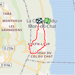
73 Le Bèlvédère du Castor (Bourget du lac)

trietsch
User

Length
4.1 km

Max alt
721 m

Uphill gradient
128 m
Km-Effort
5.9 km

Min alt
608 m

Downhill gradient
129 m
Boucle
Yes
Creation date :
2016-03-09 00:00:00.0
Updated on :
2020-01-04 20:29:56.159
1h22
Difficulty : Easy

FREE GPS app for hiking
 SityTrail
IGN / Geographical institutes
SityTrail Plus
The world is yours!
About
Trail Walking of 4.1 km to be discovered at Auvergne-Rhône-Alpes, Savoy, La Chapelle-du-Mont-du-Chat. This trail is proposed by trietsch.
Positioning
Country:
France
Region :
Auvergne-Rhône-Alpes
Department/Province :
Savoy
Municipality :
La Chapelle-du-Mont-du-Chat
Location:
Unknown
Start:(Dec)
Start:(UTM)
722238 ; 5065066 (31T) N.
Comments